Search Results for – "100% Pass 2024 CDCP: Certified Data Centre Professional (CDCP) –Reliable Testing Center 📲 The page for free download of ▛ CDCP ▟ on www.pdfvce.com will open immediately 🤣CDCP Positive Feedback"
In data 24 luglio 2015 in relazione alle attività del Gruppo di Idrogeologia è stato pubblicato un articolo sulla rivista Environmental Science and Pollution Research dal titolo “Coastal hydrogeological system of Mar Piccolo (Taranto, Italy)” a cura dei seguenti autori: L. E. Zuffianò, A. Basso, D. Casarano, V. Dragone, P. P. Limoni, A. Romanazzi, F. Santaloia, M. Polemio.
Istituto di Ricerca per la Protezione Idrogeologica – (IRPI) U.O.S. di Bari
c/o Area della Ricerca di Bari
Via Amendola, 122/I – 70126 Bari
Come arrivare
Per chi arriva in automobile:
Provenendo dall’A14:
da Nord : uscire indifferentemente al casello Bari Nord o al casello Bari Sud;
da Sud : uscire al casello Bari Sud.
In entrambi i casi, prendere la Tangenziale in direzione Brindisi ed uscire allo svincolo 13A che immette su via Amendola*. Dopo il quarto semaforo, corrispondente all’incrocio con Via Omodeo (sulla dx ponte), percorrere circa 500m e sulla dx sede area ricerca cnr, dove è ubicato l’ingresso.
Provenendo dalla Statale 100 (Taranto – Bari):
Si giunge in città direttamente su via Amendola, per cui è sufficiente seguire le indicazioni sopra riportate.
Per chi arriva in aereo:
Dall’aerostazione di Bari-Palese è possibile raggiungere il centro città con Taxi o servizio Bus navetta fino alla Stazione FS Centrale.
Per chi arriva in treno:
L’Area di Ricerca di Bari è raggiungibile a piedi dalla Stazione Centrale.
In data 6 agosto 2015 l’articolo pubblicato sulla rivista Environmental Science and Pollution Research dal titolo “Coastal hydrogeological system of Mar Piccolo (Taranto, Italy)” a cura dei seguenti autori: L. E. Zuffianò, A. Basso, D. Casarano, V. Dragone, P. P. Limoni, A. Romanazzi, F. Santaloia, M. Polemio, ha ricevuto un gradito riconoscimento da una rilevante associazione professionale americana.
Dear Maurzio:
On behalf of the National Ground Water Association, congratulations on your recently published paper, “Coastal hydrogeological system of Mar Piccolo (Taranto, Italy).”
Thanks to you and your colleagues for all of your time and your effort to make our industry that much better.
Best wishes,
Alex Beaty | Membership Services Specialist
National Ground Water Association — Advancing groundwater knowledge
601 Dempsey Road | Westerville, Ohio 43081| USA
800 551.7379 (614 898.7791) x 500 | fax 614 898.7786
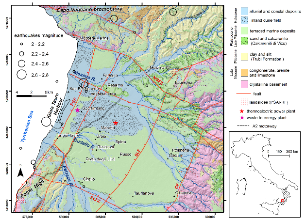
Le acque sotterranee sono il principale approvvigionamento idrico per le esigenze agricole e industriali in molte pianure costiere in tutto il mondo. Il loro esaurimento spesso innesca la subsidenza del suolo, che minaccia le infrastrutture e le attività artificiali e aggrava altri rischi geologici. Questo recente articolo appena pubblicato decrive l’applicazione di una tecnica radar ad apertura sintetica interferometrica multitemporale ai set di dati Sentinel-1 per rilevare il movimento del suolo nella piana di Gioia Tauro (Calabria, Sud Italia) dal 2018 al 2021.
L’articolo pubblicato sulla rivista Sustainability è disponibile in open access al seguente link:
Sulla Rivista Water è stato pubblicato un nuovo articolo a cura del Gruppo di Idrogeologia disponibile in versione full text open access seguendo il link:
Giorgio De Giorgio, Michele Chieco, Pier Paolo Limoni, Livia Emanuela Zuffianò, Vittoria Dragone, Annarita Romanazzi, Rossella Pagliarulo, Giuseppe Musicco and Maurizio Polemio
The use of geothermal energy resources to support anthropogenic activities have a long-lasting tradition, renewed in recent decades with the increasing use of low enthalpy geothermal energy (LEG) with combined systems of heat pumps and geothermal exchange, exploiting the enormous thermal capacity and very low temperature variability of subsoil, including rocks and water. The further potential global increase of LEG use could be enormous, although LEG is already the main geothermal energy sources in Europe, contributing significantly to reach 2030 UN sustainable development goals (SDGs) on renewable energy resources, as a further leg to support all necessary efforts for these scopes. This research pursues LEG spreading improving knowledge on limitations of guidelines, technical regulations and/or laws, briefly rules, especially in terms of potential risks or limitations due to environmental constrains or natural phenomena. A global documentary research, including scientific articles, books, technical reports from qualified institutions, technical standards, guidelines, regulations, and laws, was realized with three different groups of keywords. A total of 161 documents were selected after some steps, including quality check. Identical English and Italian keyword sets were used to span from an international global scale to the complex local scale which characterizes the Italian experience. A complex sheet was filled in for each document, supporting data discussion, planned with a geographical criterion, from global to local. The system of rules resulted worldwide inhomogeneous and complex, with high differences from countries, nations or regions, also at local scale. The low quality or the absence of simple and careful “rules” emerged an important obstacle to LEG diffusion that can guarantee sustainability and the absence of natural risks. Main virtuous systems of rules were recognized as very useful to promote LEG spreading but these are still uncommon. The discussion of optimal experiences and the overview of potential natural risks due to LEG complete the paper.
Dear Colleagues, The prospect of a word population of 9 billion by 2050, growing urbanisation, intensive irrigated agriculture and climate change will add extra pressures on the water resources and the environment. The availability of highquality freshwater is a decisive factor for socio-economic development. Water scarcity occurs in many countries— particularly in the Mediterranean, Middle East, Africa, etc.— that are confronted with a crucial combination of a severe lack of and increasing demand for high-quality water. World water resources seem abundant; however, only 0.7% of this total amount is usable water. Serious water pollution problems make 1/5 of the world’s population (approximately 1.1 billion people) at risk of water-related diseases. Competition for water made scarce by intensive irrigation is already a major source of conflict in arid and semiarid areas. Groundwater is worldwide the main source of domestic supply and irrigation. […]
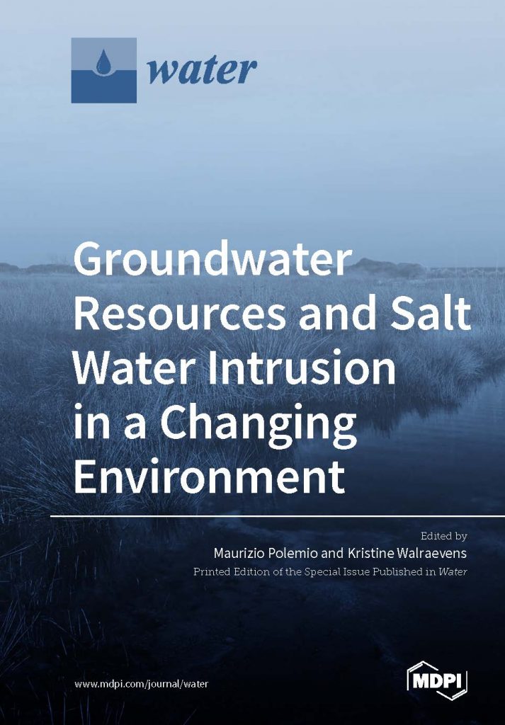
E’ stato pubblicato on line un e-book, special issue della rivista Water sulla piattaforma della MDPI Books dal titolo “Groundwater Resources and Salt Water Intrusion in a Changing Environment ” a cura di Maurizio Polemio e Kristine Walraevens. Esso approfondisce, mediante la presentazione di lavori di 30 scienziati di 11 paesi il forte impatto del cambiamento globale in termini di cambiamento climatico e pressione antropogenica con effetti fortemente negativi sulle risorse idriche sotterranee costiere, ampiamente influenzate da intrusione marina.
The characterization of the Apulian coastal wetlands due to groundwater outflow: the case of Cesine Natural Reserve (Salento)
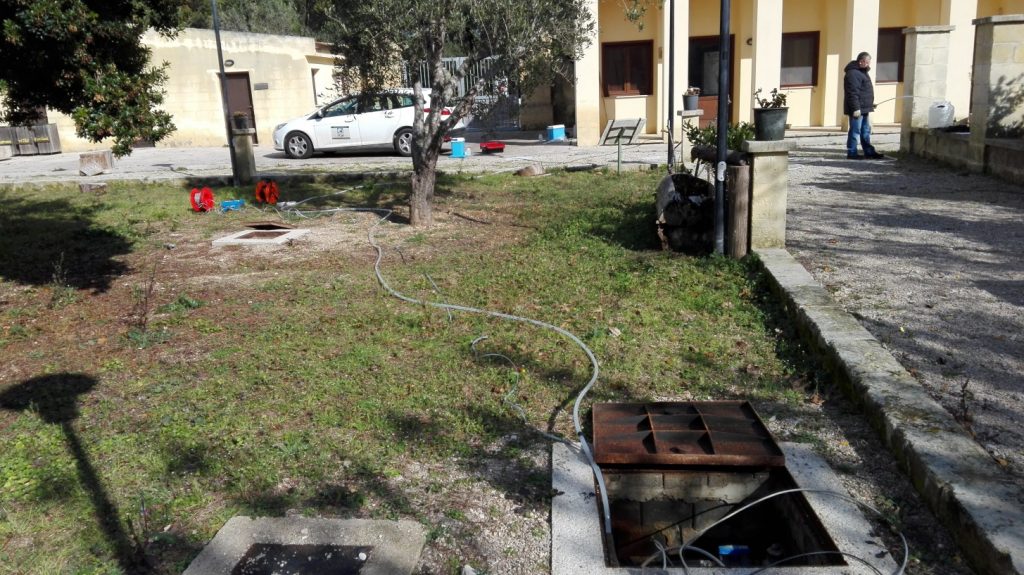
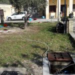
Attività di campionamento presso i piezometri posizionati nel cortile della Masseria “Le Cesine”, Centro Visite dell’Oasi – Sampling activities at the piezometers located in the garden of the “Le Cesine” Farm, Oasis Visitor Center
Le Cesine è una delle più pregevoli aree umide della costa adriatica. Collocata nel Salento in Puglia, è stata riconosciuta nel 1971 Zona Umida di interesse Internazionale e, nel 1980, Riserva Naturale di Stato; la gestione dell’intero parco naturale è stato affidato al WWF Italia.
La zona di maggior pregio naturalistico ed ambientale occupa il settore orientale, dove sono presenti le paludi d’acqua dolce e salmastra ed i principali habitat di interesse comunitario. I caratteri idrogeologici risultano molto complessi, infatti si ritiene che lungo la costa trovino efflusso tre acquiferi sovrapposti, le cui acque hanno caratteristiche chimico-fisiche molto diverse.
Al tributo sorgivo di acque sotterranee si deve in prevalenza il delicato equilibrio idrologico ed ecologico che rende di speciale interesse l’area umida delle Cesine, grazie ai quali l’ambiente si presta alla presenza di specie animali e vegetali di pregio.
In tale contesto, il Gruppo di Idrogeologia sta operando per l’affinamento delle conoscenze idrogeologiche, l’accurata definizione del modello idrogeologico concettuale e, più in generale, per contribuire alla tutela e alla salvaguardia di questa preziosa risorsa ambientale.
Cesine is one of the most valuable wetlands of the Adriatic coast. It is located in the Salento Penisula, in Apulia Region; it was recognized in 1971 Wetland of International Interest and, in 1980, State Natural Reserve; the managing of the whole nature park was entrusted to WWF Italy.
The most natural and environmental value area occupies the eastern sector, where freshwater and brackish marshes and the main habitats of community interest can be observed. The hydrogeological setting is very complex, in fact, it is believed that along the coast find outflow three overlapping aquifers, whose waters have different chemical and physical characteristics.
The tribute and constant source of groundwater must mainly the delicate balance hydrological and ecological making of special interest Cesine wetland, thanks to which the environment is suitable for the presence of valuable animal and plant species.
In this context, the Hydrogeology Group is working on the refinement of the hydrogeological knowledge, the careful definition of the hydrogeological conceptual model and, more generally, to contribute to the protection and preservation of this valuable environmental resources.
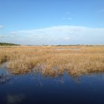
Lagoon interested by water sampling
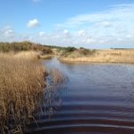
Artificial and natural channels connecting the lagoons
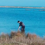
Sampling phase of the lagoonal water called “Pantano Grande”
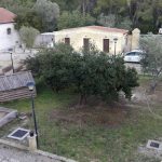
Garden of the Masseria “Le Cesine” where in addition to the hydrogeological monitoring piezometers, where the boreholes of a low enthalpy geothermal plant
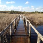
Flooded bridge that leads to the dunes and the beach of “Le Cesine” Natural Reserve.
Flooded bridge that leads to the dunes and the beach of “Le Cesine” Natural Reserve.
Garden of the Masseria “Le Cesine” where in addition to the hydrogeological monitoring piezometers, where the boreholes of a low enthalpy geothermal plant
Sampling phase of the lagoonal water called “Pantano Grande”
Artificial and natural channels connecting the lagoons
Lagoon interested by water sampling
Sampling activities at the piezometers located in the garden of the “Le Cesine” Farm, Oasis Visitor Center
We use cookies on our website to give you the most relevant experience by remembering your preferences and repeat visits. By clicking “Accept All”, you consent to the use of ALL the cookies. However, you may visit "Cookie Settings" to provide a controlled consent.
This website uses cookies to improve your experience while you navigate through the website. Out of these, the cookies that are categorized as necessary are stored on your browser as they are essential for the working of basic functionalities of the website. We also use third-party cookies that help us analyze and understand how you use this website. These cookies will be stored in your browser only with your consent. You also have the option to opt-out of these cookies. But opting out of some of these cookies may affect your browsing experience.
Necessary cookies are absolutely essential for the website to function properly. These cookies ensure basic functionalities and security features of the website, anonymously.
Cookie
Durata
Descrizione
cookielawinfo-checkbox-analytics
11 months
This cookie is set by GDPR Cookie Consent plugin. The cookie is used to store the user consent for the cookies in the category "Analytics".
cookielawinfo-checkbox-functional
11 months
The cookie is set by GDPR cookie consent to record the user consent for the cookies in the category "Functional".
cookielawinfo-checkbox-necessary
11 months
This cookie is set by GDPR Cookie Consent plugin. The cookies is used to store the user consent for the cookies in the category "Necessary".
cookielawinfo-checkbox-others
11 months
This cookie is set by GDPR Cookie Consent plugin. The cookie is used to store the user consent for the cookies in the category "Other.
cookielawinfo-checkbox-performance
11 months
This cookie is set by GDPR Cookie Consent plugin. The cookie is used to store the user consent for the cookies in the category "Performance".
viewed_cookie_policy
11 months
The cookie is set by the GDPR Cookie Consent plugin and is used to store whether or not user has consented to the use of cookies. It does not store any personal data.
Functional cookies help to perform certain functionalities like sharing the content of the website on social media platforms, collect feedbacks, and other third-party features.
Performance cookies are used to understand and analyze the key performance indexes of the website which helps in delivering a better user experience for the visitors.
Analytical cookies are used to understand how visitors interact with the website. These cookies help provide information on metrics the number of visitors, bounce rate, traffic source, etc.
Advertisement cookies are used to provide visitors with relevant ads and marketing campaigns. These cookies track visitors across websites and collect information to provide customized ads.