Search Results for – "100% Pass 2024 CDCP: Certified Data Centre Professional (CDCP) –Reliable Testing Center 📲 The page for free download of ▛ CDCP ▟ on www.pdfvce.com will open immediately 🤣CDCP Positive Feedback"

Giornata mondiale dell’acqua 2024

La Giornata mondiale dell’acqua, che si tiene il 22 marzo di ogni anno dal 1993, è un’osservanza annuale delle Nazioni Unite incentrata sull’importanza di questa risorsa. Celebrare questa giornata è sostenere il raggiungimento dell’Obiettivo 6 di sviluppo sostenibile dell’Agenda 2030: acqua e servizi igienico-sanitari per tutti.

Il tema scelto per il 2024 è “Acqua per la pace“, che si concentra sul ruolo fondamentale che l’acqua svolge nella stabilità e nella prosperità del mondo.

Il Gruppo di Ricerca di Idrogeologia darà il suo contributo partecipando al Convegno “Acqua Rivoluzione culturale” che si terra il 22 marzo 2024 a Corato (BA) presso IISS Federico II Stupor Mundi, via Teano


News n. 1 del 7 febbraio 2024

Si informa che ISPRA e SNPA hanno organizzato un evento di presentazione del “Rapporto Ambiente SNPA 2023” che si terrà il 21 febbraio p.v. dalle ore 9:30 alle 12:30 a Roma presso la Sala Polifunzionale della Presidenza del Consiglio dei Ministri Via Santa Maria in Via 37b.
Per maggiori informazioni e per la registrazione all’evento collegarsi al seguente link:
https://www.isprambiente.gov.it/it/events/presentazione-rapporto-ambiente-snpa-edizione-2023
Sarà anche possibile seguire l’evento in streaming:

National

  • 1996-1998, research project CNR-CERIST “Time series analysis and methodologies for problem Geo-Application”;

  • 1998-2001, project “Hydrogeological risk of degradation of groundwater resources and management technologies” under the 94/99 Operational Programme “Research, Technological Development and Higher Education” ESF-MURST;

  • 1998-2002, research project CNR-CERIST “The characterization of hydrogeological risk through analysis of time series”;

  • 2003-2007, U.O. CNR-GNDCI 4.14 the group was engaged in issues related to the vulnerability of aquifers;

  • 2005-2010, Research Form “Promotion and protection of water resources” of the CNR research project “Sustainability of environmental systems”;

  • 2009-2010, U.O. IRPI of the project “Development and testing of downscaling techniques and calibration of hydrological models, based on a thermo-pluviometric grid at very high resolution (1 km x 1 km) for the last 150 years, to assess the impact of climate change on water resources “funded by Euro-Mediterranean Centre on Climate Change (CMCC) to ISAC-CNR and CNR-IRPI;

  • from 2011, the research module “Qualitative and Quantitative Risk degradation of water resources”, the CNR research project “Natural hazards and anthropogenic”;

  • from 2012, the research module CNR PB.P02.001.025 “Project RITMARE (IRPI – CNR)”;

  • from 2012, Operative Unit (UO 3, Action 2, the WP, subproject 3) for the project Project Flag RITMARE (MIUR – CNR), “The Italian search for the sea”, whose activity is entitled “Groundwater and relations with the marine waters “;

  • 2016-2018, Qualitative and quantitative degradation risks of water resources and effects on human activities;

News n. 2 del 7 febbraio 2024

Si informa che è iniziata l’organizzazione del XVIII Convegno Nazionale della Sezione GIT (Geosciences and Information Technologies) e della nostra Sezione di Idrogeologia, che si svolgerà dal 17 al 19 giugno 2024 presso l’ex centrale idroelettrica “A. Pitter” di Malnisio (Montereale Valcellina, Pordenone).
Chi voglia proporre una sessione scientifica o divulgativa può comunicarlo alla segreteria GIT via mail (segreteriagit@gmail.com), fornendo:
• titolo provvisorio della sessione in italiano;
• breve riassunto (max 250 parole) in italiano;
• convener + massimo altri 3 co-conveners
La deadline per l’invio delle informazioni sopra elencate è inderogabilmente posta a domenica 18 febbraio.

Seawater Intrusion Proneness and Geophysical Investigations in the Metaponto Coastal Plain (Basilicata, Italy)

Muzzillo, R.; Zuffianò, L.E.; Rizzo, E.; Canora, F.; Capozzoli, L.; Giampaolo, V.; De Giorgio, G.; Sdao, F.; Polemio, M. Seawater Intrusion Proneness and Geophysical Investigations in the Metaponto Coastal Plain (Basilicata, Italy). Water 202113, 53

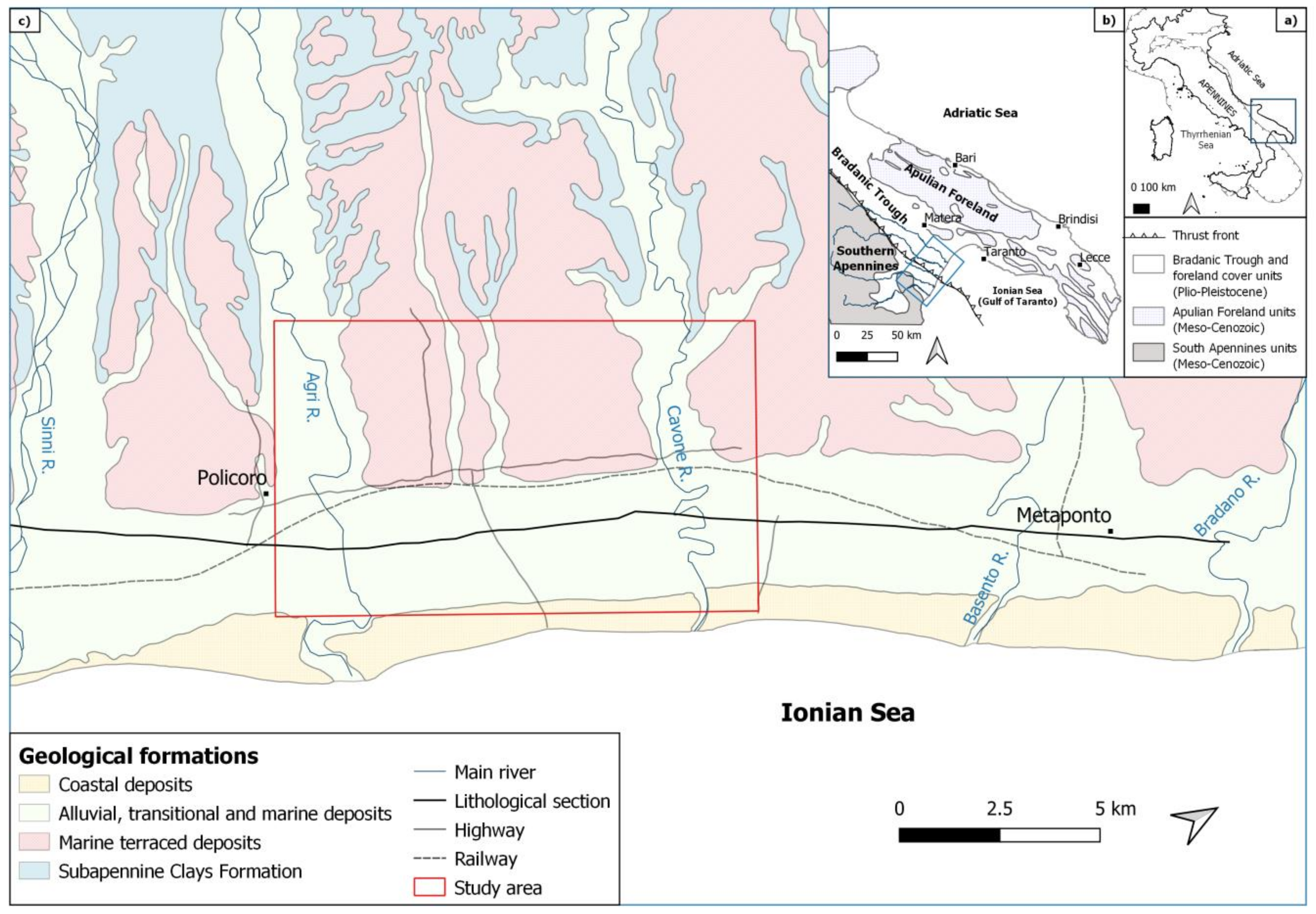
The Metaponto coastal plain extends about 40 km along the Ionian coast, between the Sinni and Bradano Rivers (southern Italy). During the 20th century, the increases in modern irrigation systems, land reclamation works, the overexploitation of wells, and agricultural and industrial activities have deeply modified land use and groundwater availability and quality along the plain. These modifications negatively impacted the natural systems in terms of groundwater and soil salinization, magnifying the risks due to seawater intrusion. In this study, we explored the proneness to seawater intrusion, testing a multidisciplinary approach based on hydrochemical and geophysical investigations. A significant portion of the coastal plain was selected for this purpose. A set of 49 groundwater samples was analyzed to define the chemical characteristics of the water and geoelectrical measurements were recorded along three long profiles. The geoelectrical surveys showed in detail the aquifer bottom pattern where it is deeply incised by paleovalleys, defining the main hydrostratigraphic features, as it is necessary to prevent seawater intrusion worsening. The hydrochemical data highlighted areas with higher seawater intrusion proneness. The acquired measurements show the high proneness to seawater intrusion, especially where the aquifer bottom is very deep below the sea level, also far from the coast, and the relevance of the detailed knowledge of the aquifer bottom in supporting any kind of management. View Full-Text


L’articolo è disponibile open access al seguente link:

Water 202113(1), 53; https://doi.org/10.3390/w13010053

Selezione per Dottorato di ricerca (PhD) – Università di Ghent (Belgio)

E’ online un bando di concorso  per l’ammissione ad un posto di PhD degree presso  l’Università di Ghent (Belgio) nella tematica “Joint inversion of physical and chemical state variable data within a multimodel subsurface hydrology framework”  presso l’istituzione scientifica “Study Centre of Nuclear Energy, Belgium, SCK-NIRAS”.

_____________________________________________________________

Info e bando di concorso:

http://academy.sckcen.be/en/Your_thesis_internship/AllTopics/Joint-inversion-of-physical-and-chemical-state-variable-data-within-a-multimodel-subsurface-hydrolog

Il termine per compilare la domanda di ammissione è il 13 Aprile 2018.

______________________________________________________________________________


Avviso di pubblicazione bando di assegno di ricerca professionalizzante

Il team di Idrogeologia si sta ampliando attraverso collaborazioni con altre istituzioni! Siamo entusiasti di ricevere le vostre candidature entro il 5 settembre. Troverete tutte le informazioni al link seguente:

https://www.urp.cnr.it/…/Bando-IRPI-010-2024-BA_signed.pdf

Infine, vi chiediamo di condividere questo post per aiutarci a darne la massima diffusione!

La scadenza è il 05/09/2024

Per qualsiasi informazione potete contattare il dott. Maurizio Polemio a questi numeri: Tel.: (+39) 080 5929584 – 3881145349

Accordo quadro di collaborazione tra Università della Corsica Pasquale Paoli e l’IRPI

Nell’ambito degli interessi istituzionali dei firmatari, è stato stipulato un accordo tra L’Università della Corsica “Pasquale Paoli” e l’IRPI focalizzato sulle seguenti tematiche: idrogeologia, idrologia isotopica, geochimica e gestione delle acque, e in particolare lo sviluppo e l’applicazione di modelli, metodi e strumenti per la gestione sostenibile ottimale. Obiettivo principale di tale accordo è la collaborazione scientifica e tecnica definendo un meccanismo in varie attività delle geoscienze, consentendo un flusso di scambio bidirezionale di dati, informazioni e conoscenze per promuovere la ricerca collaborativa nel campo delle tematiche suddette.


Image result for le cesine area umida


Sito web istituzione

https://www.universita.corsica/en/

https://www.cnrs.fr/en/cnrs


Data inizio

18/03/2021

Data fine

17/03/2025


Referente istituzione straniera

Mr. Frederic HUNEAU


Referente IRPI

Ing. Maurizio Polemio

Groundwater resources at salinisation risk: effects of climate and utilisation changes in the case of Apulian coastal aquifers (Southeastern Italy)

Seawater intrusion is the main cause of groundwater salinisation
in Italy. The largest coastal aquifers, highly vulnerable to
salinisation, are in Apulia. For these aquifers, main changes in terms
of climate change and utilisation are discussed together with piezometric
trends, as the latter are relevant triggering factors for upconing and
lateral seawater intrusion. For this purpose, time series from 1921
to 2016 concerning climate (rainfall and temperature), from 1965 to
2016 concerning groundwater availability (piezometric values), and
recent periodic data on potable utilisation are discussed. Climate and
groundwater availability trends at 2016 are compared with trends previously assessed, using the same dataset (1921-2001 for rainfall and
temperature). The negative characteristic of rainfall 1921-2001 trend
improved in the next years up to disappear in the assessment of rainfall
1921-2016 trend. Notwithstanding the improving of rainfall trend
and the reduction of groundwater utilisation, both observed at 2016,
the improvement of piezometric trends at 2016 is not enough to remove
a prevailing decreasing trend, previously observed. The increases of temperature and effective evapotranspiration should be considered a relevant explanation of groundwater availability reduction. The consequence of these results should be quickly considered in the management of groundwater resources.

The complete article is an open access on the Italian Journal of Groundwater web site:

http://www.acquesotterranee.online/index.php/acque/article/view/374

Casarano, D., Dragone, V., & Polemio, M. (2019). Groundwater resources at salinisation risk: effects of climate and utilisation changes in the case of Apulian coastal aquifers (Southeastern Italy). Acque Sotterranee – Italian Journal of Groundwater, 8(1).

https://doi.org/10.7343/as-2019-374

Partenariato di studio e documentazione a supporto dell’attività legislativa sugli Obiettivi di Sviluppo Sostenibile e focus sul geoscambio termico

Il Gruppo di Idrogeologia ha sottoscritto in questi giorni una Convenzione Operativa attuativa dell’accordo quadro tra Consiglio Regionale della Puglia e Consiglio Nazionale delle Ricerche (Deliberazione n. 153/2018 dell’Ufficio di Presidenza del Consiglio Regionale della Puglia) avente come oggetto la seguente Proposta Operativa:

“Strumenti di Studio, documentazione e ricerca a supporto delle politiche regionali verso i “Sustainable Development Goals” e test-focus sulla sostenibilità del geoscambio termico”


project-GEOSCAMBIO-evidenza


Il tema della geotermia a bassa entalpia è cruciale quale strategia di mitigazione ed adattamento ai cambiamenti climatici.
In tale ottica, si prevede la strutturazione su base territoriale di informazioni conoscitive, ambientali e realizzative, sul tema della geotermia a bassa entalpia nelle sue diverse declinazioni ed un testing di una attività di approfondimento delle attuali conoscenze sul contesto normativo e sugli effetti degli impianti geotermici sul sottosuolo e sulle acque sotterranee.

Maggiori informazioni sono disponibili sul sito del CNR IRPI al seguente link:

http://www.irpi.cnr.it/project/geoscambio/